Disaster Management Manual
A manual for practitioners and decision makers!

Disaster Management Manual
A manual for practitioners and decision makers!
Structural measures include relocation of villages to higher ground, construction of seawalls, and lock gates to make towns more resistant to tsunamis. It is also important to create a town that is easy to evacuate.
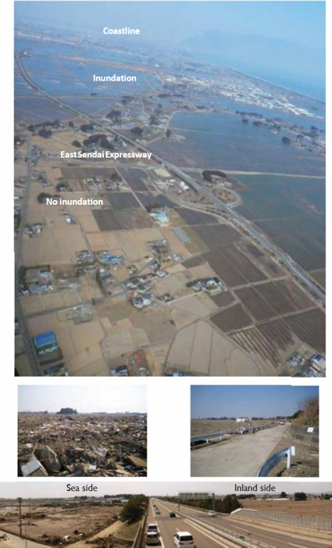
Infrastructure and public facilities such as roads, highways, and railways can be used as disaster management facilities in the event of floods, tsunamis, mudflows, and landslides. Facilities that are multifunctional are a particularly cost-effective approach to disaster management. Integrate various facilities into planning for disaster risk management (DRM). DRM plans should include a range of public facilities. For example, playgrounds and parking areas can become rescue team bases or spaces for transition shelters. Expressway embankments can become evacuation sites in the event of cyclones, floods, and tsunamis 1. Figure 4.4.6.2.1 shows the photos of the East Sendai Expressway that acts as a multi-functional road with a function of tsunami barriers.

Tsunami seawalls are designed to protect towns from tsunamis by enclosing the residential areas with high levees and blocking them from the sea. However, they are expensive to build, have a negative impact on the environment of the bay, and do not completely prevent tsunamis from inundating residential areas 1.
The primary measure against tsunamis is to move away from them. The most effective way to do this is to relocate the city itself to higher ground, which has been recommended for many years. In the areas affected by the 2011 East Japan Earthquake, housing relocation to higher ground has been promoted, especially in the areas that were severely affected by the tsunami. In order to relocate the houses to higher ground, 324 housing complexes have been constructed in 27 municipalities, and 8,389 housing lots have been built 2.
Land-use regulations, including those that relocate houses to higher ground, are successful but sometimes difficult to implement. For that reason, alternative measures need to be considered. Relocation deeply affects the livelihoods and daily lives of many people 3.
When a tsunami strikes, the primary rule of evacuation is not to move away from the tsunami along a plane, but to move up to higher ground than the tsunami.
There are towns that have been built with tsunami evacuation in mind. In these towns, the movement of people from the beach to the mountains at the time of tsunami evacuation intersects with the life path in normal time along the beach. At intersections, stopping to check left and right slows down walking speed for evacuation. Therefore, the corners of all crossroads were cut off to create streets where people can see both sides of the road while running.
In some cases, it is better for residents to build evacuation routes than for the government to do so. In one town, instead of a 15-minute evacuation route, the residents built their own route that took only six minutes.
For evacuation routes, signs that can be seen in the dark and work even during a power outage are needed, and solar-powered signs are encouraged 4.
In order to mitigate the damage caused by tsunamis, it is necessary to improve the self-defense capability of local residents against disasters through the provision of hazard information and other non-structural measures, in addition to the structural measures such as conventional development of coastal protection facilities.
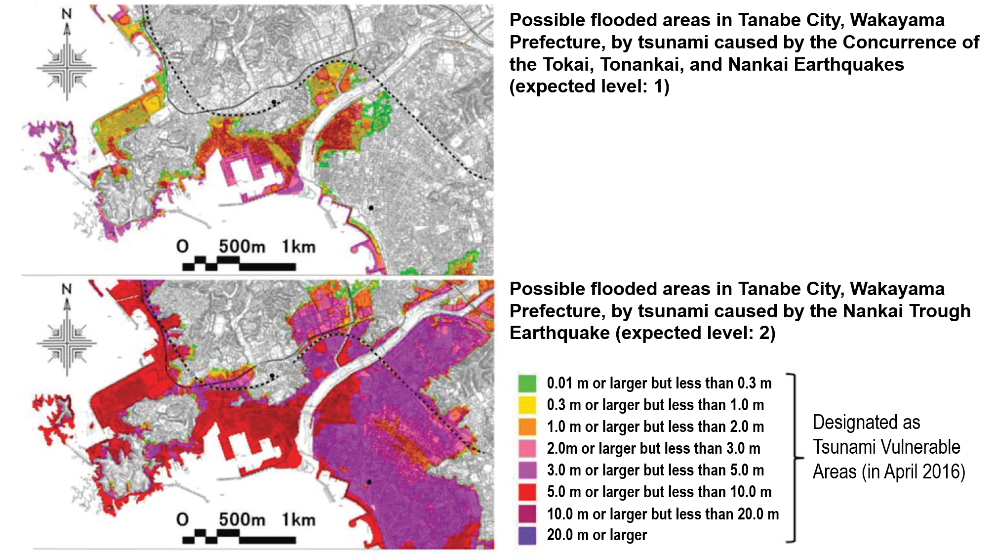
A tsunami hazard map is a map that shows the areas that are expected to be damaged by tsunamis and the extent of the damage, along with disaster prevention-related information such as evacuation sites and routes, if necessary.
Table 4.4.6.2.1 5 6 is the tsunami design considerations Japan developed after the lessons from 2011 East Japan earthquake and ensuing tsunami.
Figure 4.4.6.2.2 7 shows an example of the tsunami level considered for tsunami hazard developing.
| Frequency of Occurrence | Policy |
|---|---|---|
Level 1 | Occurring roughly once in tens of years to over a hundred years | In addition to protecting human life, the government should develop or improve coastline preservation and other facilities from the viewpoint of protecting the property of residents, stabilizing the economic activities of local communities, and maintaining production bases effectively. |
Level 2 | Occurring roughly once in hundreds of years to a thousand years | The government should establish comprehensive tsunami measures using all possible resources, giving top priority to the protection of the lives of residents, etc., and focusing on evacuation. |
Source: This table has been created using a report of the group of experts organized by the Central Disaster Management Council to investigated earthquake and tsunami measures using lessons learned from the Great East Japan Earthquake (September 28, 2011)

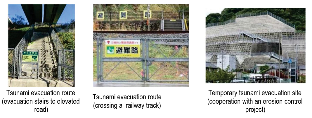
It is very important to improve facilities for evacuation in cities along the coast. Currently, tsunami evacuation facilities can be categorized into the following; 1) tsunami evacuation tower, 2) tsunami evacuation building, 3) cooperation with public projects, 4) measures against the points that interrupt evacuation, and 5) providing materials for the improvement of evacuation routes by groups in local communities with dwindling populations.
Table 4.4.6.2.2 (Selectedly referenced to 8) shows the tsunami evacuation facilities cooperated with road related projects.

Tsunamis are usually generated by great subduction zone earthquakes when the ocean floor is rapidly uplifted during the earthquake. The tsunami wave from a local subduction zone earthquake will arrive at the coast in approximately 10-20 minutes, and tsunami waves will continue to arrive periodically for several hours. When the shaking stops, people must immediately move inland to high ground. It is critical that residents and tourists know the landward extent of the local tsunami inundation zone used on evacuation brochures, their evacuation routes, and the nearest safe zones.
There are several categories of tsunami signs available:
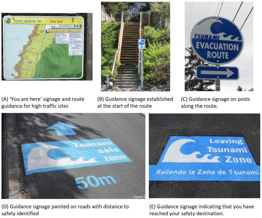
An end-to-end evacuation route plan consists of (A) ‘You Are Here’ signage and route guidance for high traffic sites; (B) guidance signage established at the start of the route used in Cannon Beach and visible from the beach, as well as signage on posts along the route; (C) signage may also be painted on roads or footpaths with distance to safety identified; and finally (D)signage indicating that you have reached your safety destination (escape point) and have left the inundation zone needs to be identified along every evacuation route (E). Table 4.4.6.2.3 9 shows the tsunami evacuation signs indicated from (A) to (E).

It is important for the government and residents to conduct disaster simulation exercises together on a regular basis. In addition to general disaster exercises, special tsunami evacuation drills are sometimes conducted. In some places, drills are held involving tourists. It is important to confirm evacuation routes and locations in advance. It is also important to consider the issue of evacuation assistance for vulnerable people, such as the elderly and those in depopulated areas.