
Countries that have experienced typhoons, torrential rains, and other wind and flood disasters, as well as massive earthquakes and tsunamis, have built "Build Back Better" after each of these past disasters to prevent another disaster from occurring, and have strengthened disaster countermeasures based on this experience.
Over the last few years, the needs of society have evolved rapidly as a result of the diversification of society and population growth. Disaster countermeasures must also change to keep up with these changes.
On the other hand, in order to cope with severe damage caused by increasingly severe weather phenomena and huge earthquakes and tsunamis that could occur at any time, it is necessary to develop technologies related to disaster prevention based on knowledge and technologies developed from past disaster experiences and to incorporate these technologies as quickly as possible.
KIOSK has collected and organized "technologies that contribute to disaster mitigation" that contribute to reducing damage to prevent the latest disasters so that it can better support the planning of disaster countermeasures in response to changes in society and recent disaster situations. It is expected that other disaster prevention measures will evolve and intensify with the use of these technologies.
KIOSK collects and organizes basic technologies from all fields that contribute to the advancement and efficiency of disaster management.
As these basic technologies are applied in practice, it is expected that disaster response from the perspective of road users will be deepened in all phases of road disaster management.

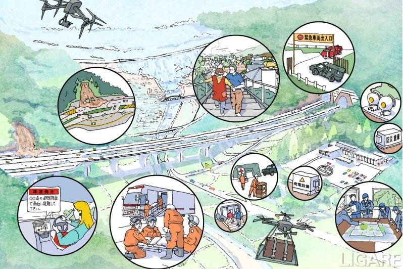
Figure 1.4.1 Roads that protect people’s lives and property from disasters (2020, “2040 Vision for Roads in Japan in 2040”, MLIT, Japan)
KIOSK collects and organizes basic technologies from all fields that contribute to Planning and Management.
The way of Planning and Management depends on the geology, ground condition, existence of natural disasters such as earthquake, flooding, landslide, etc.
Road managers should introduce the technologies properly. However, if the proper technologies were selected, it would be expected to contribute to Planning and Management.
Various technologies are described here.
In order to consider disaster management, the first step is to quantitatively evaluate and understand, as much as possible, where the vulnerabilities are and how much damage will occur in the event of a disaster.
This section introduces effective techniques for understanding disaster vulnerability.
Visualizing the risks at one glance is essential for every stakeholder in that region. 3D modeling, hazard maps, simulation and interpretation are key technologies for visualizing the risks.
KIOSK collects and organizes basic technologies from all fields that contribute to Survey and Analysis.
Generally, the damage of roads is caused by earthquake, landslide, flooding, and debris flow, etc.
Landslides, flooding, and debris flow are caused by heavy rainfall; therefore, it is necessary to pay attention to changes in rainfall due to climate change.
Various surveys and analysis are required to evaluate the condition of the site quantitatively and objectively.
Road managers should apply suitable Survey and Analysis technologies for planning suitable measures and construction.

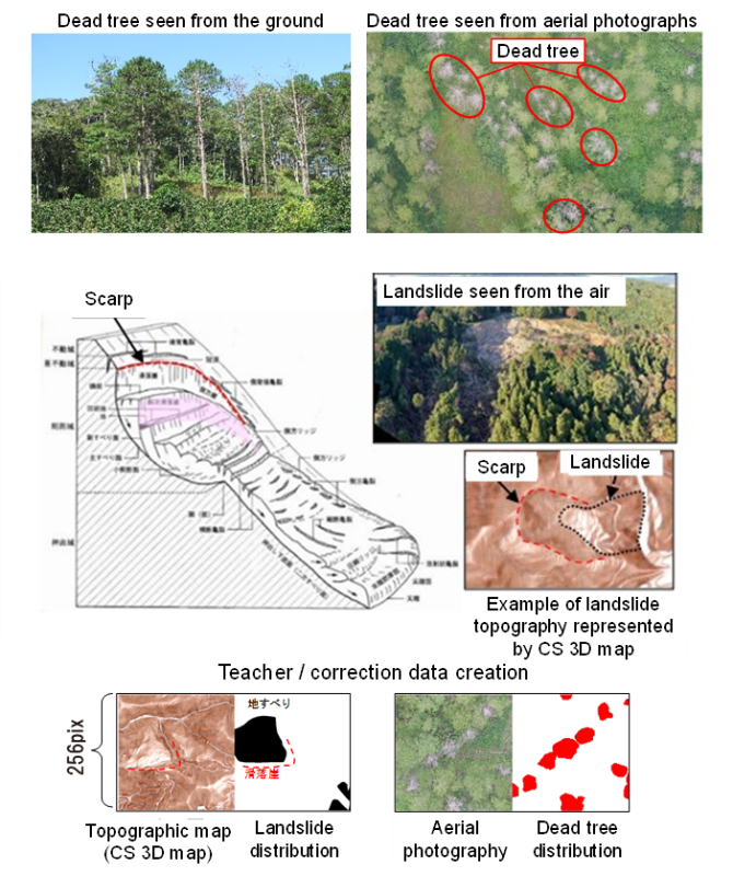
Figure 1.4.3 Example of survey and analytics of slope failure
Landslides, debris flows, and flooding are generally caused by heavy rainfall. Therefore, it is important for road managers to observe rainfall along the road in real time.
For this purpose, it is necessary to establish a system that conducts local meteorological and rainfall observations to inform road managers.
In addition, it is also necessary to combine with a system that alerts when the observed data exceeds a certain threshold level so that road managers can quickly make decisions such as traffic regulations.
Slope risks depend on the geography and geology. Geographical, geological and geotechnical survey, simulation and monitoring is necessary for mapping the location where the risks exist and assess the hazards.
During and after construction, periodical monitoring of the road and slope along the road is essential for the road management.
Earthquakes generally occur along active faults. In addition, it must be considered that disasters due to tsunami and liquefaction may occur in coastal areas and soft ground areas. Therefore, the assessment of the earthquake hazards should be carried out based on the knowledge of earth science. And combining with earthquake observation networks, and simulations of seismic intensity and tsunami height, we can estimate earthquakes, tsunamis, and liquefaction hazards that may occur in the future.
Natural disasters are mainly caused by earthquakes and heavy rains. But there might be a possibility that disaster factors other than earthquakes and heavy rains might cause hazards.
In this section, other disaster factors, which are not described in 1.4.3.1 – 1.4.3.3, are described.
KIOSK collects and organizes basic technologies from all fields that contribute to Measures and Construction.
To construct roads that are resistant to natural disasters, it is necessary to carry out proper construction works based on appropriate design. At the same time, there is a demand for considering not to damage the landscape when designing and constructing.
It is also important to continuously monitor the condition of the built roads, during the construction, to keep the safety and manage the construction works.
Various technologies are described here, but it is expected to implement the suitable Measures and Construction.

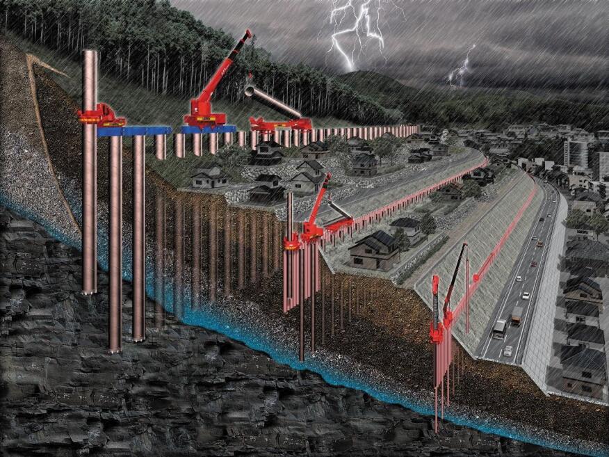
Figure 1.4.4 Example of slope collapse prevention construction
Embankment is a man-made structure. Unlike natural ground that has been formed over a long period of time, man-made structure is constructed in a short period of time. Generally, its strength and toughness are weaker than natural ground. Therefore, it is needed to apply enough compaction to the soil or/and apply a soil improvement to construct the embankment, which has enough strength and toughness.
In this section, ground improvement related technologies are described here.
When a road is constructed along a slope, it is required that suitable measures are taken to prevent the slope failure. And recently, there are many cases where greening work, which takes into consideration the environment, is also combined with current slope failure prevention works. With the recent development of sensor technology and robot technology, early warning systems and robotic construction work techniques are developed that enable them to conduct construction works more safely.
When a road is constructed along a rock fall area, it is required that suitable measures are taken to prevent the rock fall. With the recent development of sensor technology combined with numerical analysis techniques, monitoring techniques and early warning systems are updated. That enables road managers to conduct measures and construction works more effectively.
Generally, debris flow suddenly attacks a road and it is difficult to predict its occurrence. Therefore, both detecting and protecting technologies should be implemented at the location where there is a high debris flow risk. The key is to detect the debris flow in real time and transmit the data or alert as quickly as possible to road administrators or directly to personnel who drive cars. Also, debris barriers are effective facilities for protecting roads.
There are two targets to which an enhancing earthquake resistance technique should be applied. The first one is to improve the earthquake resistance of the structure itself, and the second one is to improve the earthquake resistance of the ground where the structure is constructed. The important thing is to check that these earthquake-resistant construction techniques are properly applied. For checking them, inspections and diagnostics are required to be carried out during and after the construction works.
Soft ground related technologies are mainly consisting of ground improvement technologies. In urban area, there are many obstacles underground. To keep the safety and effectiveness of the construction, several ground improvement technologies which include control drilling techniques or newly developed equipments are developed.
There are two aspects for emergency measures. One is the early warning before disasters occur. And the second one is a quick survey of the damage caused by disasters. For this purpose, many early warning systems and monitoring systems have been developed. Since it is necessary to investigate huge areas in a short time, non-destructive testing methods and robot-based technologies have been implemented.
KIOSK collects and organizes basic technologies from all fields that contribute to Maintenance.
For maintaining roads, it is important to monitor the changes quantitatively that have occurred not only in the road itself, but also in the surrounding ground and slopes.
Monitoring data will be essential for establishing the proper maintenance planning.
In addition, it is necessary to have a warning system such as for traffic restriction in case of emergency.
For this purpose, monitoring technology is important, and many monitoring methods are described in the content here.

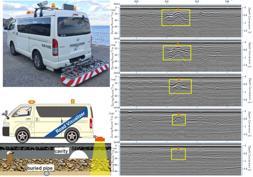
Figure 1.4.5 Example of road surface monitor
Since, the total length of the road is long, road maintenance is generally expensive and time-consuming matters. Because of the limited budget for maintenance, it is essential to identify severely damaged areas of the road to determine the priority zone for the maintenance when making the maintenance plan.
For evaluating the road surface and roadbed condition various inspection and diagnosing techniques have been developed.
As the inspections and diagnoses are carried out regularly, acquired data should be accumulated in a database or cloud-based data storage system. This is important for maintenance for the long term.
The bridge consists mainly of iron and concrete. In the case of bridges where those are constructed along coastal areas, it is necessary to take into account chemical erosion of the materials due to chloride damage.
By observing the presence of cracks on the bridge structure, chemical analysis of the material, stresses which apply on the structure, etc. the bridge can be quantitatively assessed.
Recently BIM is utilized for construction works, these data are expected to be reflected in BIM. Then the maintenance planning and works would be performed effectively.
Tunnel is mainly constructed in mountainous area and underground in urbanized areas. Since, the surrounding geology varies from hard rock to soft soil, the design of the tunnel is varied.
But in any case, a tunnel should have enough strength against underground pressure or dynamic forces caused by earthquakes.
In addition, in case of fire caused by a traffic accident, fireproof measures should also be considered.
Slope measures aim to stabilize the slope itself to prevent the failure of the slope. To achieve this, monitoring is quite essential to grasp the condition of the slope.
Many monitoring technologies could be applied for slope. Since the observed area is wide, a huge volume of the observed data should be interpreted in real time. The interpretation using AI technologies would be next generation techniques for the future.
Since, the total length of the road is long, road maintenance is generally expensive and time-consuming matters. Because of the limited budget for maintenance, it is important to identify the location and condition of the road structure where it is severely damaged.
For evaluating the road structure, inspection and diagnosing techniques have been developed.
These techniques are effective for maintenance work for the long term.